
Google Earth AI Images Hit a Trust Crisis
 Vortixel
15 minutes read
Vortixel
15 minutes read
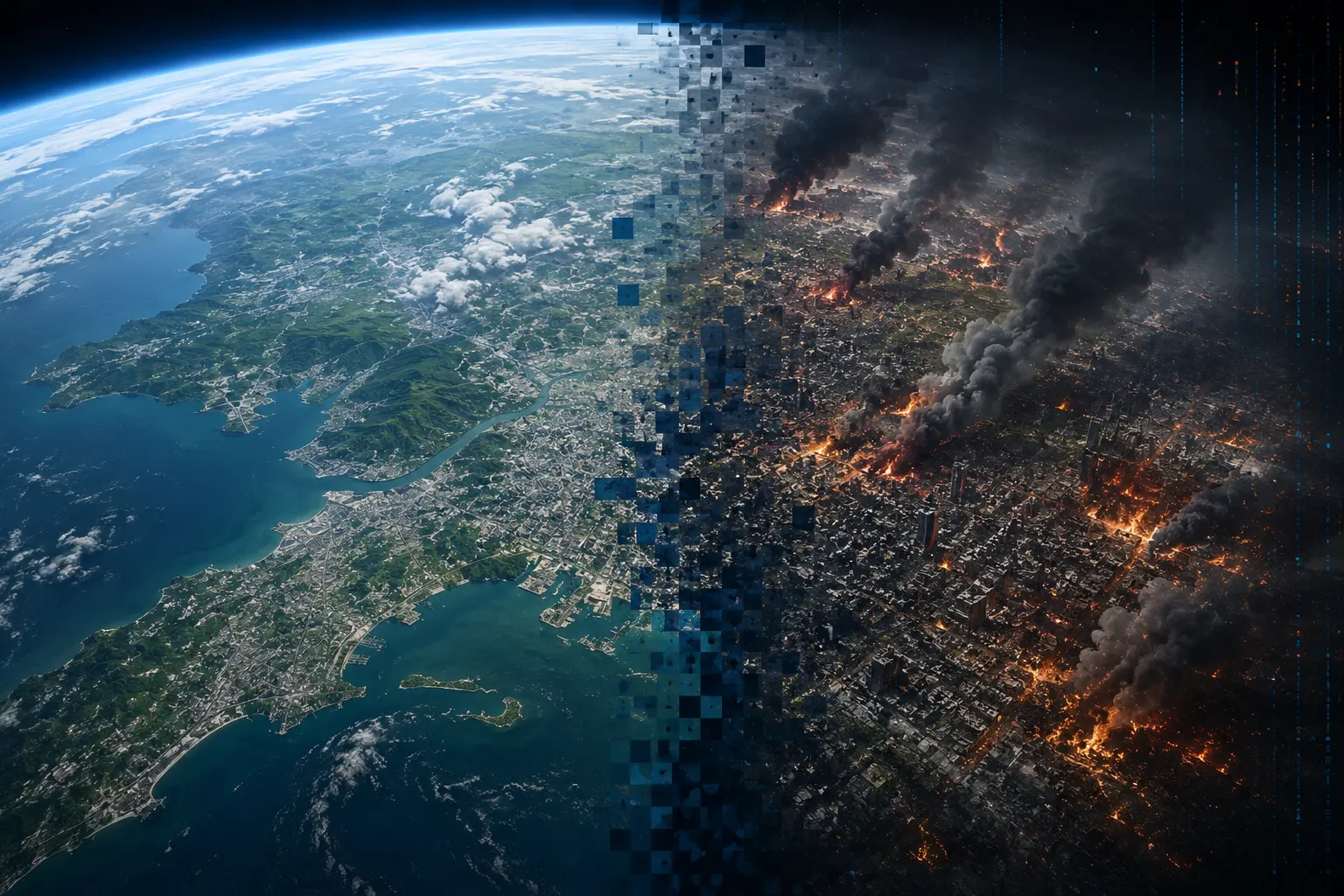
For years, opening Google Earth felt like borrowing a window into reality. You could glide above a coastline, inspect a city block, revisit a childhood neighborhood, or study a distant conflict zone without physically leaving your desk. That sense of visual truth made the platform useful far beyond casual exploration, turning it into a working tool for journalists, researchers, designers, educators, emergency teams, and open-source investigators. Then Google briefly introduced a feature that allowed users to generate new visuals over real locations with artificial intelligence. The arrival and rapid removal of Google Earth AI images revealed how quickly creative experimentation can become a crisis when synthetic media is placed inside a platform people already trust.
The feature sounded futuristic in the most exciting way possible. Instead of merely observing a location, users could type instructions and create an imagined version of it using existing satellite, aerial, and three-dimensional mapping data as a visual foundation. A planner might visualize trees covering an empty street, an architect could imagine a new structure, and a climate researcher could illustrate how flooding might reshape a neighborhood. Those uses made the technology feel like a powerful bridge between geospatial information and generative design. The problem was that the same tool could also create scenes of destruction, military activity, humanitarian emergencies, or public disorder that had never actually happened.
Within hours of the release, researchers began testing the darker edge of the system. They demonstrated how ordinary text prompts could transform familiar places into convincing scenes of conflict, disaster, migration, or infrastructure damage. Although the results were not inserted into the official public imagery seen by every Google Earth visitor, screenshots could still be exported, cropped, reposted, and separated from their original context. Once that happened, the visual carried the emotional authority of satellite evidence without necessarily carrying its disclosure labels. Google responded by withdrawing the feature and saying it would work on stronger safeguards after generated outputs appeared to violate company policies.
Why Google Earth AI Images Felt Different
Generative image tools are already everywhere, so the controversy was not simply about software producing something fake. People regularly expect synthetic visuals from dedicated AI art platforms, editing apps, and experimental creative tools. Google Earth sits in a completely different psychological category because its core experience is built around representations of real places. Users approach it expecting geographic accuracy, even while understanding that imagery may be old, stitched together, color-corrected, or captured from different sources. Adding realistic generation to that environment blurred a boundary that had previously been easy to understand.
That boundary matters because credibility is partly inherited from the interface surrounding an image. A fictional city shown inside a game engine feels fictional because the environment signals that expectation. A manipulated landscape shown through a familiar mapping platform may feel documentary even when a small label says otherwise. People do not evaluate every pixel independently; they rely on logos, layouts, captions, visual styles, and previous experience to decide what deserves trust. By allowing generated scenes to emerge from Google Earth data, the feature risked transferring the platform’s reputation to content that represented imagination rather than observation.
This is one reason the backlash arrived so quickly from open-source intelligence communities. Investigators often use satellite imagery to verify attacks, track construction, study environmental damage, identify military movements, and compare claims against visible changes on the ground. Their work already requires careful attention to dates, shadows, weather, terrain, metadata, and image provenance. A mainstream tool capable of producing believable geographic fabrications adds another layer of uncertainty to that process. It does not make genuine satellite evidence useless, but it raises the cost of proving that an image is authentic.
The One-Day Experiment That Moved Too Fast
The speed of the rollback became part of the story. Technology companies often test experimental products for weeks or months before public criticism forces a major change, but this feature barely had time to settle into users’ workflows. Its removal showed that the risk was not theoretical or buried in a distant future scenario. People immediately understood how realistic geographic editing could be weaponized in a fast-moving news cycle. Google’s decision also suggested that internal safeguards had not fully anticipated how aggressively users would stress-test the system once it became publicly accessible.
To be fair, the tool was not released without protections. Generated visuals reportedly included digital watermarking designed to identify content created or altered by AI, and the synthetic images were not quietly replacing official Google Earth imagery. Those choices showed an awareness that users needed a distinction between captured reality and generated possibility. However, technical disclosure can weaken when an image leaves the environment where it was created. Screenshots lose interface cues, social platforms compress files, metadata can disappear, and people can intentionally crop out visible warnings.
Watermarking is useful, but it is not a complete social defense system. A hidden marker only helps when a compatible detector is available, trusted, and actually used by the person evaluating the content. A visible label can be cropped away, covered, or dismissed as part of the surrounding interface. Even accurate detection may arrive too late when a dramatic fake image travels through group chats and social feeds within minutes. The emotional impact occurs at first contact, while correction often requires a slower and more deliberate process.
Satellite Deepfakes Raise the Stakes
Most public conversations about deepfakes focus on faces, voices, and celebrity impersonations. Geographic deepfakes operate differently because they target places rather than personal identity. A fabricated satellite image can imply that a bridge collapsed, a military base expanded, a forest burned, or a refugee camp appeared near a border. Viewers may treat the image as distant and objective, especially when it resembles the overhead perspective associated with surveillance, scientific observation, or professional mapping. That apparent distance can make the manipulation feel more credible rather than less.
The danger becomes sharper during wars, elections, natural disasters, and diplomatic crises. In those moments, the public wants immediate visual proof, but reliable information often arrives slowly. A synthetic overhead image can fill that gap before journalists, governments, or independent analysts have verified what happened. The first image to dominate a conversation can shape emotional reactions even after experts disprove it. Satellite-style misinformation therefore has the potential to influence markets, public safety decisions, political narratives, and attitudes toward entire communities.
There is also a major difference between producing a fake from scratch and editing a real geographic foundation. A completely generated landscape may contain obvious inconsistencies that reveal its artificial origin. When an AI system begins with recognizable streets, rivers, airports, landmarks, and terrain, much of the scene is already accurate. The model only needs to add one convincing fictional element for the entire composition to tell a false story. This mixture of authentic context and invented detail can be harder to challenge than an image that is synthetic from edge to edge.
The Trust Problem Goes Beyond Google
Google’s rollback should not be read as proof that one company uniquely failed to understand generative AI. It reflects a wider industry pattern in which impressive capabilities move from research demonstrations to consumer interfaces faster than social norms can form around them. Product teams naturally focus on what a model allows people to create, while safety teams must imagine how those same abilities could be misused at scale. The creative possibilities are easy to demonstrate in a polished launch video. The harmful possibilities often become obvious only when thousands of users start experimenting in public.
This tension is central to the future of artificial intelligence in visual platforms. Companies want tools that feel powerful, intuitive, and unrestricted enough to inspire users. At the same time, the most flexible systems are often the most difficult to control through simple prompt filters. Blocking a list of violent words is not enough because harmless language can still describe misleading scenarios. A sophisticated user can reframe a request, combine multiple edits, or use seemingly neutral objects to construct a deceptive final image.
The controversy also shows why safety cannot be separated from product identity. A risky feature inside an entertainment app may require one level of protection, while the same feature inside a mapping, medical, financial, or educational service requires another. Users bring different expectations to each environment. Google Earth is not merely a blank canvas with geographic textures; it is a platform associated with observation and orientation. Features placed inside it must therefore preserve the distinction between evidence, simulation, and artistic invention with unusual clarity.
What the Feature Could Have Done Well
The legitimate creative value of location-based generation should not disappear from the discussion. Urban designers could use it to quickly illustrate bike lanes, parks, pedestrian zones, solar installations, or alternative building layouts. Teachers could visualize historical landscapes, students could explore future climate scenarios, and filmmakers could develop location concepts before expensive production work begins. Disaster-response teams might create training simulations that help communities understand evacuation routes or infrastructure vulnerabilities. These applications show why the idea attracted interest before the trust problem overwhelmed the launch.
For visual creators, the technology could reduce the distance between imagination and spatial planning. Instead of building a rough composite manually, a designer could describe an idea and receive a geographically grounded concept in seconds. That workflow could make early experimentation faster and more accessible to people without advanced three-dimensional modeling skills. It could also help clients understand proposals that are difficult to communicate through technical drawings alone. The challenge is preserving these benefits without making the outputs easy to confuse with real-world documentation.
A safer version might treat generated scenes more like simulations than edited satellite photographs. Strong visual frames, persistent labels, altered color treatments, and clear separation from official imagery could make the imaginative status obvious. Exported files could carry durable provenance information alongside a visible disclosure that survives ordinary sharing. The system might also restrict generation around active conflict zones, critical infrastructure, emergency events, or politically sensitive locations. None of these measures would remove every risk, but together they could prevent the interface from lending synthetic scenes an undeserved documentary appearance.
Why Detection Alone Will Not Save Us
It is tempting to believe that better AI detectors will eventually solve the problem. Detection research is improving, and specialized systems can identify patterns that human eyes often miss. Yet the competition between generation and detection behaves like a moving target because image models continue to improve and malicious actors deliberately modify outputs to avoid recognition. A detector that performs well on one model or image format may struggle after cropping, compression, filtering, or rescaling. False positives also matter because wrongly labeling authentic evidence as synthetic can be almost as damaging as accepting a fake.
The more durable solution will likely combine technical provenance, platform policy, professional verification, and public media literacy. Cameras and software can record how an image was captured or edited, while publishing platforms can preserve and display that history. Newsrooms and research organizations can adopt clearer standards for authenticating geographic evidence before publication. Schools can teach people to evaluate dramatic visuals without treating every polished image as immediate proof. Users must also become comfortable with uncertainty, especially when an image appears during a rapidly developing event.
This does not mean ordinary people need to become forensic analysts. A few practical habits can significantly reduce the chance of spreading a false geographic image. Viewers can look for the earliest known upload, check whether reputable organizations have confirmed the event, compare the scene with other imagery, and examine whether dates or landmarks make sense. They can also pause when a visual seems perfectly designed to provoke outrage, fear, or triumph. The most dangerous misinformation often succeeds because it reaches emotion before it reaches critical thinking.
Practical Lessons for Visual Creators
Designers, editors, and content creators should treat geographic AI imagery as a high-context medium. A generated city concept used in a clearly fictional campaign is different from a synthetic disaster scene posted without explanation. The closer a visual comes to news, public safety, politics, or real-world evidence, the stronger its disclosure should be. Creators should avoid relying on tiny labels that disappear on mobile screens or after reposting. The disclosure needs to remain understandable even when the image is viewed outside the original website.
Teams should also save prompts, source files, generation dates, editing histories, and the models used during production. That documentation creates an internal chain of accountability and makes it easier to answer questions if a visual is misunderstood. It can also help organizations distinguish approved concept art from materials intended for factual communication. Clear file naming is surprisingly important because synthetic and authentic assets often end up mixed inside shared folders. A professional workflow should assume that context will eventually be lost unless the context is deliberately preserved.
Publishers need guidelines that go beyond a generic rule telling staff to label AI content. They should define when geographic generation is allowed, which subjects require additional approval, and which scenarios should be avoided completely. A lifestyle illustration of a futuristic park may be low risk, while a generated military installation near a real border is not. Editorial teams should also decide how to handle photorealistic visuals that combine genuine mapping data with synthetic objects. The strongest policy is one that helps creators make good decisions before publication rather than punishing them after confusion spreads.
What Platforms Should Learn From the Rollback
The first lesson is that a watermark cannot carry the full weight of trust and safety. Platforms should design disclosure as an experience rather than a hidden technical feature. Users need to understand what they are creating, how others may interpret it, and what happens when the visual leaves the original product. Export restrictions, persistent framing, contextual warnings, and friction around sensitive prompts can all contribute to safer behavior. The system should make responsible use easier than deceptive use, not merely state that deception is prohibited in the terms of service.
The second lesson is that red-team testing must reflect the identity of the product. Testers should not only search for prohibited images in isolation; they should examine how the platform’s existing credibility changes the meaning of those images. A fake explosion produced inside a generic art generator is harmful in one way. The same explosion shown over a recognizable city through a trusted geospatial interface carries a different level of persuasive force. Safety reviews need to measure that inherited authority before a feature reaches the public.
The third lesson is that feedback from specialist communities should arrive before launch whenever possible. Journalists, geospatial analysts, human-rights researchers, emergency responders, and misinformation experts understand risks that may not appear during ordinary product testing. Inviting them into controlled evaluations could reveal how an experimental tool might disrupt real verification workflows. Their concerns should influence design decisions, not simply appear as reactions after release. Early consultation may slow a launch, but rebuilding lost trust is usually slower and more expensive.
A Turning Point for Visual Innovation
The Google Earth episode may become a reference point for how visual AI products are evaluated. Until recently, many image-generation debates centered on copyright, artistic labor, bias, and nonconsensual imagery. Those issues remain urgent, but geographic generation introduces another category: the integrity of visual evidence about the physical world. As models become capable of editing complex scenes with natural language, nearly every trusted visual platform will face similar questions. The industry must decide where creative freedom ends and evidentiary responsibility begins.
This moment may also push visual technology toward clearer modes. A platform could offer an observation mode for authentic imagery, a simulation mode for analytical scenarios, and a creative mode for artistic experimentation. Each mode could use distinct interfaces, export formats, labels, and permission levels. That separation would not eliminate manipulation outside the platform, but it would reduce accidental confusion inside it. Users should never need to guess whether they are viewing recorded reality, a data-driven projection, or a fully generated scene.
There is a business advantage to getting this distinction right. Companies that protect the credibility of their products can become trusted partners for governments, researchers, media organizations, educators, and enterprises. Those customers may accept limitations when the limits preserve reliability. By contrast, a platform that repeatedly blurs authentic and synthetic content may gain short-term engagement while weakening the value of its core data. Trust is not an obstacle to innovation; for products built around real-world information, trust is the infrastructure that makes innovation useful.
The Future Requires More Than a Pause Button
Pulling the feature was the responsible immediate response, but removal alone does not resolve the underlying challenge. Generative geographic tools will return in some form because their value for design, planning, education, entertainment, and research is too significant to ignore. Other companies may build similar products even if Google chooses a slower path. The real question is whether the next generation will arrive with safety built into its structure rather than added after public backlash. A pause creates time, but only thoughtful redesign can create confidence.
That redesign should acknowledge how content actually travels online. A generated image rarely stays inside the interface where it was produced. It moves through screenshots, presentations, messaging apps, social feeds, news reports, and reposts stripped of their original descriptions. Safeguards must therefore survive ordinary transformations and remain useful to viewers who never interacted with the creation tool. The product should be evaluated not only at the moment of generation but throughout the entire life cycle of the visual.
The controversy ultimately tells a larger story about the current AI era. We now have tools capable of turning almost any idea into a polished visual before society has agreed on how those visuals should be interpreted. That power can expand creativity, improve communication, and help people explore possible futures. It can also manufacture convincing evidence for events that never happened. The distance between those outcomes is often determined less by the model itself than by the context, interface, safeguards, and intentions surrounding it.
Conclusion: Trust Must Be Designed Into AI
The rapid rise and removal of Google Earth AI images was more than a brief product mishap. It exposed the unique danger of placing generative media inside a platform that millions of people associate with geographic truth. Google’s rollback showed that even watermarks and policy rules may not be enough when synthetic visuals can be detached from their original context and circulated as apparent evidence. It also demonstrated that the creative potential of geographic AI is real, especially for planning, education, design, and simulation. The next version of this technology must protect those benefits while making the difference between reality and imagination impossible to overlook.
Visual innovation will continue moving fast, but speed alone cannot define progress. A tool is not truly advanced when it creates impressive images while forcing everyone else to question whether trusted evidence can still be believed. The better future is one where creative systems make possibilities visible without disguising those possibilities as recorded fact. That will require stronger product design, durable provenance, informed policies, specialist testing, and more careful sharing habits from users. Google Earth’s one-day experiment may have ended quickly, but the trust debate it triggered is only beginning.